The East African Marine Transect Expedition
In the East African region, coral reefs contribute significantly to coastal productivity, provide valuable resources for coastal communities and offer a lifeline to millions of people in Africa’s East Coast. For four months the Moving Sushi team decided to head up along the coastline on a boat, diving underwater to build a critically important dataset and open source it for everyone to use.
A
year before our boat officially hit the waters to set sail the idea for the
East Africa Transect was formed, as all slightly nutty expedition ideas seem to
be, around an evening fire side chat between a group of friends in the bushes
of Mozambique. All of us were keen divers, fisheries and ocean scientists and
in love with all things ocean related so the conversation naturally flowed towards
our individual work and some of the issues we were facing. Whether it was the
heat, the salt water or the perfectly peaceful African night I don’t know we got
onto the topic, but suddenly we drifted into thinking up expedition ideas. We
wanted to see if somehow, using a very minimal budget, we could gather a team
together of young enthusiasts to begin a coastal survey of the coral reef
fishes and corals, spanning 3 500 km of coastline from northern South
Africa to northern Kenya, and do it in 4 months. The aim was to provide a quantitative baseline
dataset for the entire East African region and to try and provide scientific
research that perhaps could improve our knowledge of the East African coral
reef ecosystems.
Coral
reefs are highly complex and productive ecosystems, incredibly rich in
biodiversity- second only to tropical rainforests. But coral reefs in many
areas are heavily overexploited and often data deficient for a large variety of
reasons. To obtain a baseline dataset on such a large geographic scale would
require a mammoth research undertaking, understandably the reason why no such standardised
dataset had yet been collected along the entire East African region, until now.
To do this we were going to need a team of 6 divers, 3 people in each dive team, a filmmaker, boat and crew and travel up the coastline diving and collecting data. The process of data collection involved us using a reliable, standardised, quantitative survey technique. Enter the scuba diver-operated stereo video system, developed by SeaGIS in Australia. The stereo video setup consists of two high-definition digital video cameras in underwater housings, mounted on a solid crossbar and positioned approximately 0.8 m apart, which as you swim along, records all the fishes encountered within a given census area. This method of counting and analysing fish biodiversity reduces many of the biases associated with the more traditionally used visual census techniques, and is a very coast effective and easily replicated meaning that others would be able to repeat our survey in their own areas and we would be able to get a better picture of what was happening in our reef systems over time.
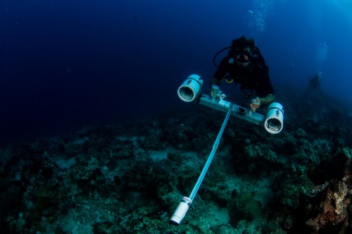
Dr. Rhett Bennett using the stereo-video cameras during a reef transect survey dive.
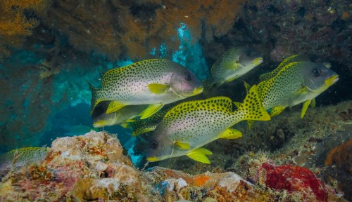
During the expedition we found reefs of immense beauty and it was inspiring to see.
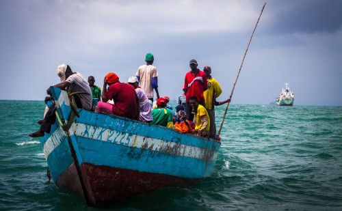
Intense fishing effort was also evident and the use of destructive gears like ring nets and dynamite was rampant.
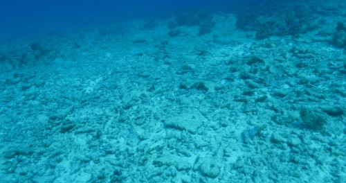
Despite observing incredible areas of biodiversity, large portions of the reef is destroyed beyond repair. How fast has this happened? What is the extent of the damage biologically and socially?
It was quite an ambitious idea, and the only people we could lure in and commit their unpaid time to get the job done were our close friends. After much cajoling, shameless bribery and with the promise of adventure we eventually had our team, and what we thought would be our vessel, as we left the shores of Durban to begin our underwater odyssey. David Livingstone wrote on one of his African expeditions, “If you have men who will only come if they know there is a good road, I don't want them. I want men who will come if there is no road at all.” And not within a day of setting sail did this quote suddenly become a bit of a mantra that would follow us through the next few months.
Very quickly seasickness took a grim hold of the
boat. Everyone was a deep fifty shads of green, with all on board mentally
plotting anywhere else in the world they would rather be, if only it was
possible to move three inches without being sick. It was relentless and without
escape we moved for hours slowly into a pounding headwind.
The weather turned from mildly unpleasant to downright terrifying. We found ourselves 1nm (1.8miles) off Leven Point in the North coast with a broken engine and at the front of a major storm, that over the coming 12 hours would grow to a force 10 storm, with wind speeds exceeding 100km/h accompanied by 20ft waves which ended up snapping a boom. Being on the boat was like riding a roller coaster, with none of us getting much sleep until what felt like an endless age the storm eventually abated. We limped back into Richards Bay, with a broken boat after not even 1 week on the trip. Things went from bad to worse as we had to divide the team up – three heading up to friends in Mozambique to try and get the survey dives started, while the rest remained behind with the boat awaiting on repairs and spare parts. The plan was to reunite in Mozambique, where we would have to dive aggressively before cyclone season hit in order to still hit our targets. But we made do and pushed on, after all we could not give up so easily. Mountains were moved, feet were tapped and somehow the boat team got it together and in a week we had managed to get the boat back into working shape. Spirits were high as we sailed out – expedition on the water take 2. But unfortunately it seems we were going to be plagued by hard, testing times.
Just as we had the boat newly repaired and had made up for lost time, crawling towards Tofo, Mozambique after days of sailing, there was an ominous giant ‘thunk’ late one night from the bowels of the boat. Our hearts sank and the engine stopped working again, this time completely. Finding justifications for our faltering expedition was becoming increasingly difficult as once again the boat was rendered broken and we had to remove all our gear and our entire expedition team into a small house on a hill overlooking Inhambane- marooned and heading nowhere at a rapid rate. There was very serious talk of packing it all in and calling it a day.
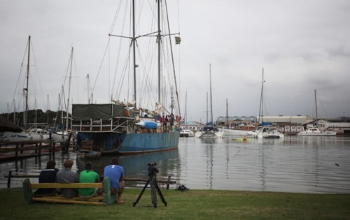
Team looking over original expedition vessel, which would fail catastrophically in the 1st month of the expedition.
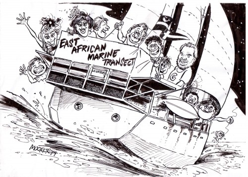
Local cartoonist depicts the expedition as we set sail from the Bluff Yacht Club just joust of Durban central.
Our biggest challenge was finding all the dive locations. Sometimes, and more often than not, we were working on scant information and heading into areas that had not really been dived before. Sans a GPS point and with the clock ticking locating the right spots to dive on becomes a very tense affair. Making decisions on what direction to head to, which side of an island to dive off of or how much time we can spend on certain location became a daily stress filled ritual around the boat, everyone trying (and sometimes failing) not tread on toes or frayed nerves. We had to quickly to learn not to second-guess our decisions or spend precious minutes playing the “what if “ game. Every hour that went by just served to remind us how far we still had to go to get a 4-month expedition that we now only had 2 months to get in the bag.
Everyone was required to dig deep into reserves at times we were not even certain we had. To say this wasn’t a pleasure cruise would be an understatement, a big one. But slowly, and with everyone supporting each other as best as we could, the dive sites began to be ticked off. Each time we crossed out another site on the list we had set up on the door of the boat’s main cabin everyone hopes were raised. You could still feel the tension in the cabins as we hit normal minor setbacks (sickness, fatigue, loosing some members to actual paid work) but now as the days went by there was a definite lifted atmosphere.
Maybe this is what adventure is all about? Being able to face your fears and failures, but not let them alter the fundamentals of why you chose to walk out the front door in the first place.
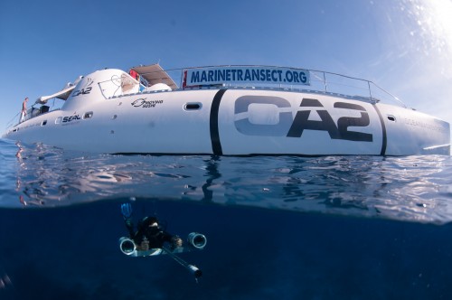
Dr. Bennett diving below the expedition recovery vessel Ocean Adventurer 2 with the setero-video set.
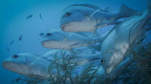
Stereo-video allows for accurate measurements of fish, meaning that biomass can be calculated, and biomass is a ket metric.
In February of 2013, weather beaten, slat encrusted, smelly and a little skinnier we made it back to the safety of Cape Town harbour. We had managed a grand total of 224 survey dives and 26 recreational and filming dives in rapid succession. We were beat, but we were successful and that would not have happened without the help of so many different people along the way, who fed, housed, motivated and encouraged us to never give up on why we were doing what we were. I find that with every expedition we do we come across the same kinds of people – and I always tell Mike that if we ever come across similar people limping around our neck of the woods we will be the first to take them in and give them a shower, bed and food as so many have done for us. You have no idea the difference it makes.
So after all that drama what did we end up discovering in our time underwater?
While no two dives were the same, a common thread began to emerge as the slow process of data analysis went on for another year while we each reflected on what we had been through and seen under the east Africa waters.
- Encouragingly we observed some reefs in near pristine condition. High fish diversity and well-developed coral communities with endless large, old coral heads were an absolute privilege to dive on –leaving quite a few of us with the impression we were diving one some of the best dive sites in East Africa. There were also numerous reefs exhibiting little evidence of fishing, with large predatory fishes and herbivorous fishes still in high abundance. Potato groupers, large snapper species and higher overall abundance of fishes of a wide range of size classes and trophic levels showed us that certain well-established no-take zones in Mozambique, Tanzania and Kenya were really effective in the protection of important fishery species. An argument that is in favour of well-managed marine no-take zones as a useful fisheries management tool for the future.
- But we were also spotting the signs of overexploited reefs in areas closer to coastal access points and around well-established local fisheries. Less large predatory fishes and a creeping dominance by algal cover, pointed to evidence that even the herbivorous fishes have been overexploited – a sure sign of the effects of net and spear-fishing. With the larger predatory fishes disappearing local fishers resort to potentially more effective and devastating gears as they redirect their efforts towards smaller target species and species in lower trophic levels, such as spearfishing to access large parrotfishes and small-mesh gill nets to target shoals of fish too small to take a baited hook. On more than one occasion we dived up against a massive monofilament gill net, un-fondly referred to as ‘hanging walls of death.’
- In addition, the corals themselves, in many areas, have been devastated by the destructive effects of dynamite fishing, an illegal practice entered into considerably more boldly than one might expect. Being underwater when one of these homemade bombs goes off sends a jarring pain through your bones, which happened to us on a regular basis while we dived in Tanzania, even though the practice is illegal. The destruction this kind of fishing does is total and devastating, leaving behind eerie uninhabited craters of coral rubble.
- What is most disturbing, however, is that many of these observations of coral damage and nets were recorded during dives conducted within some form of marine reserve or no-take zones. We can only surmise that there is either a lack of knowledge and/or respect for protected area boundaries, or ineffective management.

A small trailer edited by the Goodwork Picture Company for the East African Marine Transect Expedition (made before the data analysis was completed).
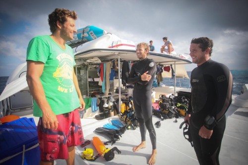
Rhett, Caine and Mike going over div observations, the smiles a sense of accomplishment in the face of adversity.
What are the next key steps?
- There is a critical need to build on the data collected during the expedition.
- Building on the data means creating a comparative database so that trends can be calculated and predictions developed.
- Understanding how the coral reef ecosystem is adapting to climate change and anthropogenic forces is vital if we want to be sustainable.
- Engage in a second expedition to replicate the EAMT expedition.
- In replicating the expedition the scientific boundaries must be extended to incorporate fish health index.
- Must finish the data assessment of coral reef transect images, and build new databases during the repeat expedition.
- Aim to make this expedition part of a long term monitoring program.


